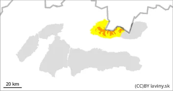
In the Western Tatras there is an increased avalanche danger for positions above 1700m above sea level, i.e. 2nd degree of the 5-part international scale. In this mountain there is sometimes more than 50cm of new snow in the lee of the mountains. Especially dangerous are the couloirs and couloirs oriented to the northeast, east, southeast to south with a slope of over 30°, the slopes below them are also dangerous! Wind-coiled cushions and soft slabs of new snow can be loosened with just a small additional mechanical load (e.g. by a single skier, snowboarder). It is also possible for small and medium avalanches to release spontaneously, especially where there was already a continuous snow cover before the last snowfall.
Snowpack
dp.6: cold, loose snow and wind
In the Western Tatras during the last snowfall period (Friday-Saturday-Sunday) up to 50cm of new snow was added in places. In the cold north-westerly flow during these days the air temperature remained in the range of -10 to -15 °C. The new snow remains powdery and is intensively moved by strong winds, of course it is thus unevenly distributed. The total height of the snow cover above the forest line varies between 40 and 130 cm. On leeward, predominantly east- and south-facing slopes, wind-blown new snow is deposited in pillows and soft slabs, which are dangerous on steep slopes.
Tendency
Avalanche danger is expected to persist.
Compiled by Ivan Chlebovec
Danger level
1500m
Avalanche Problem
Wind slab
1500m
Beware of wind-blown new snow!
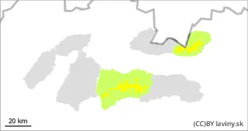
In the High Tatras and in the Ďumbier part of the Low Tatras, a moderate avalanche danger is declared for positions above 1500m above sea level, i.e. the 2nd degree of the 5-part international scale. A lot of new snow is being deposited by wind into pillows and soft slabs in the north-east, east, south-east to south oriented couloirs and troughs. In the High and Low Tatras there is about 30cm of new snow. Especially steep to extremely steep troughs with a slope above 35° are a danger. The release of small, even medium-sized avalanches is likely especially with high additional loads (e.g. walking, skier's fall, etc.).
Snowpack
In the High and Low Tatras 15 - 30 cm of new snow was added during the last snowfall period (Friday-Saturday-Sunday). The total height of the snow cover in some places reaches 1m. In the cold north-westerly flow during these days, the air temperature was in the range of -10 to -15 °C.
The new snow remains powdery and is intensively moved by strong winds, which of course makes it unevenly distributed. On leeward, mainly east- and south-facing slopes, the wind-blown new snow is deposited in pillows and soft slabs, which are dangerous on very steep slopes.
More snow is forecast for tomorrow, but with little precipitation.
Tendency
Avalanche danger is expected to persist.
Compiled by Ivan Chlebovec
Danger level
treeline
Avalanche Problem
Wind slab
Treeline
Beware of wind-blown new snow!
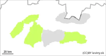
In the Fatra Mountains and in the Kraljehoľa part of the Low Tatras, a low avalanche danger is declared, i.e. level 1 of the 5-part international scale. New wind-blown snow is deposited in the mainly east-facing mounds on older hard and rough surfaces. Unstable pillows and soft slabs of small thickness are formed. Steep to extremely steep slopes with gradients of more than 35° are a hazard. Small avalanches are likely to be triggered by large additional loads (e.g. foot traffic, skier falls, etc.).
Snowpack
In the Fatra Mountains and in the Kraljehoľa part of the Low Tatras 10 - 30 cm of new snow was added during the last snowfall period (Friday-Saturday-Sunday). In the cold north-westerly flow during these days the air temperature was in the range of -5 to -10 °C. The new snow remains powdery and is intensively moved by strong winds, of course it is thus unevenly distributed. The total height of the snow cover varies between 15 and 60 cm.
On leeward, predominantly east and south-facing slopes, the wind-blown new snow is deposited in pillows and soft slabs. These are dangerous on those steep slopes where a thicker continuous snow cover has already been established before this snowfall.
More snow is forecast for tomorrow, but with little precipitation.