Danger level
 | 1600m |
|  |
|  |

![]()
Watch out for fresh wind-blown snow!
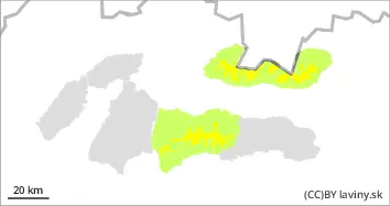
In the High, Western and Ďumbier part of the Low Tatras there is a moderate avalanche danger, i.e. the 2nd degree of the 5-part international scale, for positions above 1600m above sea level. A lot of new snow is being deposited by the wind into the north-east, east, south-east to south oriented couloirs and troughs on top of the previous pillows and slabs. There is 20cm of new snow in the High and Low Tatras and 30cm in the Western Tatras. Especially steep to extremely steep troughs with a slope above 35° are a danger. The release of small, even medium-sized avalanches is likely especially with large additional loads (e.g. walking, skier's fall, etc.).
Snowpack
dp.6: cold, loose snow and wind
In the High and Low Tatras about 20cm of new snow has been added during the last two days, in the Western Tatras 30cm of new snow. The total height of the snow cover in some places already reaches 1m. The snowfall is taking place in still cold weather with temperatures around -10°C. The new powder snow is falling on hardened ground and is also being moved by the WNW winds into mainly east-facing mounds and troughs. Here, cushions and soft slabs are formed which are not firmly bonded to the harder substrate. More snow is forecast on the mountains during Sunday with a stronger NW flow, with 10-15°C predicted for more new snow.
Tendency
With persistent snow and wind, the avalanche danger is increasing.
By: Ivan Chlebovec


