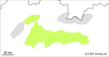
Danger level
 | 1800m |
|  |
|  |

![]()
Watch out for fresh wind-blown snow!
In the High and Western Tatras, a moderate avalanche danger is declared for positions above 1800m above sea level, i.e. the 2nd degree of the 5-part international scale. In the moguls and troughs oriented to the northeast, east to southeast, new wind-blown snow is deposited on top of previous pillows and slabs. Steep to extremely steep couloirs with slopes above 35° are a particular hazard. The release of small, even medium-sized avalanches is likely with large additional loads (e.g. foot traffic, skier falls, etc.). At lower altitudes there is a relatively small amount of new snow on well-stabilised older ground.
Snowpack
dp.6: cold, loose snow and wind
In the High and Western Tatras, the snow cover ranges from 50 to 90 cm from the middle positions. Approximately 10 cm of new snow fell during Friday. The previous snow cover is well stabilized up to an altitude of about 2000m, at higher altitudes there are older forms of less stable wind blown snow in the east facing moguls and troughs. New snow is redeposited in the north-westerly flow in predominantly east-oriented slopes. The snow is falling with steady winds and cooling. Snow pillows and soft slabs form in leeward areas, which are not well bonded to the firm ground.
Tendency
With snowfall forecast, a slightly increasing avalanche danger.
By: Ivan Chlebovec