Watch out for wind-blown snow on hard ground and a permanently weak layer on the northern sector!
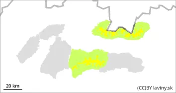
In the High, Western and Western part of the Low Tatras there is a moderate avalanche danger, 2nd degree, at altitudes above 1700 m above sea level. Here, due to snowfall and strong winds in the previous days, unstable snow slabs and pillows have formed, especially in the northern orientations. The new snow and wind-blown slabs are deposited on the old hard base, with which it is not sufficiently bonded. In the northern sector, there is also an unstable layer of square-grained snow in the snow profile at the highest elevations. u Avalanche can be released in steep and very steep terrain. Occasional smaller spontaneous avalanches are possible.
Snowpack
The older snow cover is mostly well consolidated and settled. It has received 10 to 20 cm of new snow in recent days. It is unevenly distributed, especially in the northern sector. Hard slabs alternate with puffy pillows of new snow. During Tuesday, we expect a gradual increase in cloud cover, with the 0°C isotherm reaching 1200 m above sea level. Snow cover continues to be well below average, especially at elevations up to 1600m.
Tendency
With the expected weather patterns persisting.
Danger level
Avalanche release is possible only sporadically.
In the Fatras and the eastern part of the Low Tatras there is only a small avalanche danger, 1.degree. Up to 10 cm of new snow has fallen above the forest line, which lies on hard ground and is not sufficiently well bonded with it. Smaller avalanches can only be released exceptionally, and only on steep and very steep slopes; their risk is of pushing a person into exposed terrain.
Snowpack
The surface of the snow is 5-15 cm of new snow from the last snowfall, which lies on an older hard surface. Due to the fluctuations of the 0°C isotherm, the snow is mostly frozen and stabilised. The total snow cover is well below average, usually less than 50 cm. In gullies and moguls in isolated places even more.
Tendency
with the expected development of the weather persisting.