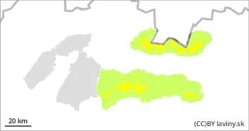
In the High, West and Low Tatras at altitudes above 1700 m above sea level there is a moderate avalanche danger, 2nd degree. Here, due to snowfall and strong winds in the previous days, unstable snow slabs and pillows have formed, especially in the northern orientations. The new snow and wind-blown slabs are deposited on the old hard base, with which it is not sufficiently bonded. The avalanche can be released in steep and very steep terrain with only a small additional load. Occasionally, smaller spontaneous avalanches are possible.
Snowpack
The older snow cover is mostly well consolidated and settled. It has received 10 to 20 cm of new snow in recent days. It is unevenly distributed, especially in the northern sector. Hard slabs alternate with puffy pillows of new snow. In the next few days it will cool down slightly, the 0°C isotherm will drop to 1200 m above sea level, causing a crust to form in the mid-altitudes. Snow cover remains well below average, especially at altitudes up to 1600 m above sea level.
Tendency
Persistent
Danger level
1400m
Avalanche Problem
Wet snow
1400m
Avalanche release is possible only sporadically.
There is only a small avalanche danger in the Fatras, 1st degree. Up to 10 cm of new snow has fallen above the forest line, which lies on hard ground and is not sufficiently well bonded with it. Smaller avalanches can only be released exceptionally, and only on steep and very steep slopes.
Snowpack
The surface of the snow is 5-15 cm of new snow from the last snowfall, which lies on an older hard surface. Due to the fluctuations of the 0°C isotherm, the snow is mostly frozen and stabilised. The total snow cover is well below average, mostly less than 50 cm. There is of course more in the gullies and moguls.