Danger level
 | 1700m |
|  |
|  |

![]()
Watch out for wind-blown snow on hard ground and a permanently weak layer on the northern sector!
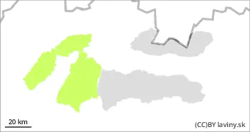
In the High, Western and Low Tatras there is a moderate avalanche danger, i.e. 2nd degree, at altitudes above 1700 m above sea level. Here, due to snowfall and strong winds in the previous days, unstable snow slabs and pillows have formed, especially in the northern orientations. The new snow and wind-blown slabs are deposited on the old hard base, with which it is not sufficiently bonded. In the northern sector, there is also an unstable layer of square-grained snow in the snow profile at the highest elevations. u Avalanche can be released in steep and very steep terrain. Occasional smaller spontaneous avalanches are possible.
Snowpack
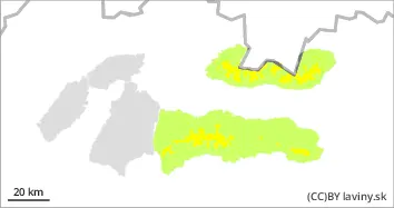
During Wednesday we expect windy weather and gradually increasing clouds, moderate warming with precipitation, isotherm 0°C will reach 1300 m above sea level. Older snow cover is mostly well consolidated and settled, except in the northern sector where unstable snow types are present in the profile. Between 10 and 20 cm of new snow has fallen on the hardened base in recent days. This is unevenly distributed, especially in the northern sector. Hard slabs alternate with puffy pillows of new snow. On the ridges, overhangs have formed. Snow cover remains well below average, especially at altitudes up to 1600 m above sea level.
Tendency
with the expected weather development ploughed