Danger level
 |
|  |  |

![]()
When it gets colder, BEWARE of dry, windslab lying on top of the frozen layer of snow from yesterday's thaw.
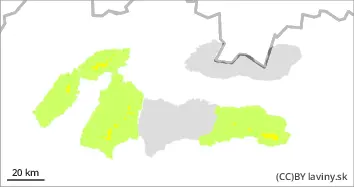
In the High, Western and Low Tatras there is a MODERATE avalanche danger, 2nd degree. The snow cover froze and stabilized after the passage of the cold front. However, there is new snow on its surface from the receding snowfall, which has been transported to the leeward slopes, under saddles, ridges and rock faces due to the very strong NW winds. In these places, the release of slab avalanches is possible, especially with higher additional loads. Occasionally, smaller to medium-sized spontaneous avalanches are also possible. Avoid places with large amounts of wind-drifted snow!
Snowpack
The snow cover became waterlogged during Saturday's warming and rain up to 1500-2000 m above sea level (higher in the east, lower in the west). It froze and stabilized after the passage of a cold front in the evening. The post-cooling snowfall is accompanied by strong NW winds, causing its deposition on leeward (mainly SE) locations. At the highest altitudes of the Tatra Mountains (above 2000 m) it snowed also during Saturday, 15-25 cm of new snow fell here. The total amount of snow at altitudes below 1500 m is below average.
Tendency
As a result of the receding snowfall, PERSISTENT