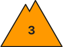
Danger level
 |
|  |  |

![]()
this is a special alert
this is the headline
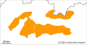
In the High and Western Tatras the second degree of avalanche danger persists. In the Low Tatras and in the afternoon! in the Fatras, the avalanche danger level will increase to 3. i.e. increased. From 1700 m, the main problem is wind-blown snow, which has created inflated slabs of varying hardness on leeward slopes, in places under saddles, rock walls, and in steep couloirs above 35°. Their release is possible with high additional loads (walking, jumping, falling). Especially S, SE and E orientations are dangerous. The second avalanche problem is wet snow. The snow cover is soaked to a critical layer in some cases down to the ground due to rain. Here, avalanches are at risk of being released with only a small additional load on all orientations. Spontaneous medium avalanches are expected, occasionally even large avalanches from wet snow.
Snowpack
Tomorrow, a warm air flow from the southwest will peak in our area. From the morning, mostly small, gradually increasing cloud cover. In the afternoon gradually cloudy to cloudy and in many places rain or showers, snow at altitudes from about 1700 m. Very warm! At high altitudes of 1500-2500m 3 to -4°.Winds of 10 to 19 m/s. At lower altitudes the snow cover is soaked due to heavy rain and not very suitable for skiing or hiking. At higher altitudes the snow cover is very unevenly distributed due to the wind. The snow is mainly transported to the S, SE and E slopes. Snow will fall at favourable temperatures, which will make the new snow bind well with the old snow. Please note that the weather will deteriorate as the day progresses!
Tendency
Permalink