Watch out for wet snow on S orientations, locally smaller snow pillows of new snow can be found on the S sector.
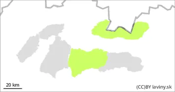
In the High, Western and Western part of the Low Tatras there is a low avalanche danger (1st degree). The snow will harden at night and will melt during the day due to the influx of warm air and sunlight, especially in the middle altitudes on the southern exposures. Due to the partly cloudy weather, melting will not be as pronounced as on previous days. At the highest altitudes, we also recorded snow showers in local places during the previous day (Thursday). Here there is wet new snow in a small thickness (5cm). The current situation is well discernible on the ground, watch out for a greater thickness of waterlogged snow, on the S exposures of the highest altitudes, on the other hand, watch out for isolated snow pillows of puffy snow.
Snowpack
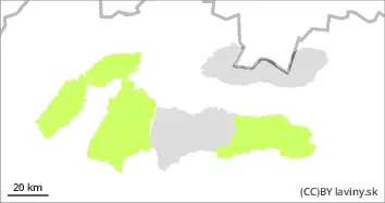
The weather on Friday will be influenced by the edge of a pressure high and a breaking cold front It will continue to be very warm, with temperatures reaching positive numbers at altitudes below 1900 m a.s.l. The snow will harden overnight and then soften again during the day, especially in the mid-altitudes. Occasional light snow showers may occur during the day. On the northern side of the mountains, in the case of shaded areas, the snow still retains a powdery character. The snow cover is well below average, especially at altitudes up to 1500 m above sea level.
Tendency
Permalink
BL
AM Danger level
PM Danger level
Avalanche Problem
Wet snow
Watch out for wet snow on southern exposures.
In the Fatras and the eastern part of the Low Tatras there is a low avalanche danger (1st degree). The snow will harden at night and will melt during the day due to the influx of warm air and sunlight, especially in the middle altitudes on the southern exposures. Due to the partly cloudy weather, melting will not be as pronounced as on previous days. During the previous day (Thursday) we also recorded localised precipitation, but due to the high temperatures it was of a rainy nature in these mountains. The current situation is well discernible on the ground, watch out for a greater thickness of waterlogged snow.
Snowpack
The weather during Friday will be influenced by the edge of a pressure high and a breaking cold front It will continue to be very warm, with temperatures reaching positive numbers at the highest elevations. Snow will harden overnight and then soften again during the day, especially in the mid-latitudes. Isolated light precipitation may occur during the day. snow cover is fine over most of the area and hardening in the morning. Snow cover is well below average, especially at altitudes up to 1500 m above sea level.