Watch for wet in the mid-elevations, snow will start to fall at the highest elevations from midday.
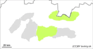
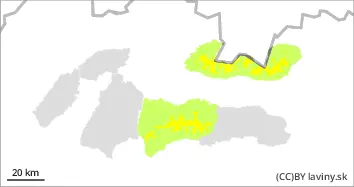
Moderate avalanche danger (2nd degree) is valid in the High and West and western part of the Low Tatras from noon. The snow will harden at night and will melt during the day due to temperatures, especially in the middle altitudes. A cold front and light snowfall are expected to arrive during the day. Up to 5 cm of new wet snow will fall at the highest altitudes. Avoid areas where blowing snow from snowfall is evident or narrow steep couloirs.
Snowpack
The weather during Thursday will be influenced by the edge of a pressure high and a passing cold front. It will continue to be very warm, with temperatures reaching positive figures below 2000 m a.s.l. The snow will harden overnight and then soften again during the day, especially in the mid-altitudes. Light snowfall is expected during the day, with a maximum of 5cm of new wet snow. On the northern side of the mountains, in shaded areas, the snow still retains a powdery character. The snow cover is well below average, especially at altitudes up to 1500 m above sea level.
Tendency
Permalink
Danger level
Avalanche Problem
Wet snow
The passage of a cold front will bring precipitation in the form of rain.
In the Fatras and the eastern part of the Low Tatras there is a , low avalanche danger. The snow will harden at night and will melt during the day due to temperatures. During the day we expect a cold front and light precipitation in the form of rain. The main problem is the wet snow.
Snowpack
The weather during Thursday will be influenced by the edge of a pressure high and a passing cold front. It will continue to be very warm, with temperatures reaching positive numbers even at the highest elevations. Snow will harden overnight and then soften again during the day. . We expect precipitation during the day, but it will also be rain at the highest altitudes.