Danger level
 |
|  |  | |||||
|  |
|  |


![]()
Beware of significant warming during the day - snow will become heavier, possible spontaneous avalanches
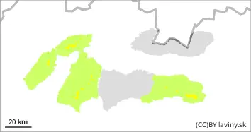
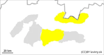
Moderate avalanche danger (2nd degree) is valid in the High and Western and western part of the Low Tatras. The main avalanche problem is wet snow on steep sunny slopes. Caution, on the eastern slopes the snow may get wet even in the morning. On the north side of the highest elevations, there is still a consistently weak layer in the snow profile. The current terrain situation calls for good decisions, avoid steep areas, watch for a heavier layer of melted snow, but also avoid areas where blown snow from the last snowfall is evident and has not fallen with an avalanche in previous days. In the event of an avalanche release, avalanches of medium to large size, even spontaneous avalanches, are a risk.
Snowpack
The weather is very warm and sunny. Temperatures will reach positive numbers even at the highest altitudes. Snow will harden overnight and then soften again during the day. On the northern side of the mountains, in shaded areas, the snow still retains its powdery character. At the highest points (above 1800 m), there is a permanently weak layer of square-grained snow on the northern side of the mountains. The snow cover remains well below average, especially at altitudes below 1500 m.
Tendency
rising during the day, decreasing as evening approaches, weakly decreasing overall