Watch out for weak layers on northerly orientations.
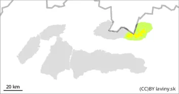
Moderate avalanche danger (2nd degree) is declared in the high altitudes of the High Tatras. The danger is concentrated on the northern and shady orientations on the northern side of the mountain. Avalanche release is possible on very steep slopes. Deeper in the profile there is a weak layer of dangerous square-grained snow. At altitudes below 1700 m the snow was soaked at the beginning of last week and therefore hardened and stabilised due to the cooling.
Snowpack
The snow cover is generally packed and hardened . With warming and subsequent cooling, the surface is hard, load-bearing, and in places crusted, which is breaking through. This hard surface has received between 3 and 5 cm of powdery snow, which is not bound to the hard layer. At the highest altitudes, the hard crust is followed by loose, square-grained snow, which is the most serious problem, especially in the northern sectors where the surface is not sufficiently load-bearing.
Tendency
no significant change
Danger level
treeline
Avalanche Problem
New snow
Treeline
Persistent weak layer
Treeline
New snow on hard ground
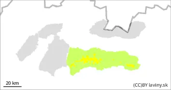
Moderate avalanche danger, level 2, is mainly concentrated above the forest boundary. New snow accumulation of 10cm is expected, locally up to 20cm. This will not be well bonded to the hard base layer. Avalanche release will be possible even with small additional loads mainly with point detachment. Spontaneous avalanches may also form during the day as the weather gradually warms up.
Snowpack
The older snow cover is mostly well consolidated and settled. Deeper in the snow cover there is a layer of old angular snow which poses only a very localised risk. Up to 20cm of new snow is expected to be added locally on top of this hard surface, which will not be interbedded with the underlying layer.
Tendency
Snowfall and gradual warming is increasing.
Danger level
Avalanche Problem
Persistent weak layer
New snow
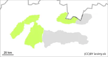
Avalanche release is possible only sporadically.
Occasionally there is a thin layer of square-grained snow deep in the snow cover. Due to the overall low snow depth and the small number of dangerous spots, there is only a low avalanche danger. Up to 10 cm of new snow may fall on the hard and sometimes icy surface. This will not be well bonded to the base layer.
Snowpack
In the profile there is occasionally a weak layer of square-grained snow. The surface of the snow is hard wearing, in places crust that is breaking through. Up to 10 cm of new snow is expected to fall on this hard surface.