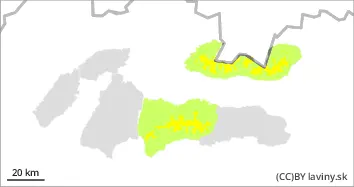
There is a MODERATE avalanche danger in the High, Western and Low Tatras above the 1700 m above sea level.
During the last snowfall, 10 to 25 cm of new snow fell. This is a main avalanche problem, especially on steep slopes at high altitudes and on sunlit slopes. Avalanche release is possible with higher additional loads, but smaller spontaneous avalanches from wet snow are also expected to occur, especially on sunny slopes. Also watch out for smaller avalanches related to extreme terrain and terrain traps.
Snowpack
During Wednesday and the following night, 10 to 25 cm of new snow fell in the region, mostly in light to moderate winds. The accumulated snow slabs are only localized. Old firn snow is under the new snow at altitudes above about 1500 m above sea level. The snow cover is slightly hardened in the morning, during the day in sunny weather it becomes significantly wetter and its stability decreases.
Tendency
Rising as the day warms up. FK
AM Danger level
1400m
Avalanche Problem
New snow
1400m
PM Danger level
1400m
Avalanche Problem
New snow
1400m
Wet snow
1400m
In the eastern part of the Low Tatras and in Krivanská Mala Fatra there is a SMALL avalanche danger.
Due to the recent snowfall (10 to 20 cm), there is a possibility of avalanches on steep slopes. Both with higher additional loads, but also smaller spontaneous avalanches and slides, especially with warming temperatures and sunshine in the midday hours.
Snowpack
The snow cover is mostly made up of new snow. Only at the highest altitudes and in troughs is there old firn snow under the new snow. When the weather warms up and the sun shines during the day, the new snow becomes wetter, reducing its stability.