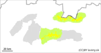
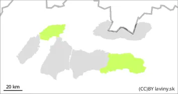
Moderate avalanche danger (2nd degree) in the High, Western and Low Tatras above 1600 m asl
Due to the recent snowfall (10 to 20 cm), there is a possibility of avalanches on steep slopes. Both with greater additional loads and smaller spontaneous avalanches, especially with warming temperatures and sunshine in the midday.
Snowpack
Between 5 and 20 cm of new snow should fall at altitudes above 1200 m above sea level during Tuesday and overnight. It will be evenly distributed, stronger winds are not expected. The air temperature at 1500 m above sea level will rise to 0°C. During the day, the snow will become wetter on sunlit slopes, reducing its stability on steep slopes. At altitudes above 1500 m, the old snow cover, consisting of firn snow, will be under the new snow.
Tendency
slightly rising during the day. FK
Danger level
1400m
Avalanche Problem
New snow
1400m
Wet snow
1800m
In the eastern part of the Low Tatras and in Krivanská Mala Fatra there is only a SMALL avalanche danger (1st degree).
Due to the recent snowfall (5 to 15 cm), there is a possibility of avalanches on steep slopes. Firstly, with higher additional loads, but also smaller spontaneous avalanches and slides, especially when it gets warmer and sunny in the afternoon.
Snowpack
The snow cover is mostly made up of new snow. Only at the highest altitudes and in troughs is there old firn snow under the new snow. When the weather warms up and the sun shines during the day, the new snow becomes wetter, reducing its stability.