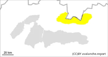
Snowfall with winds will produce slabs on south and southeast aspects!
The main avalanche problem is new snow. The heavy snowfall is coming from the north, so it will hit the High and Western Tatras the most. The wind direction will be north to north-westerly, therefore snow slabs and pillows will form on the south-eastern slopes. Initially it will rain in the foothills and at middle altitudes, but gradually the rain will change to snow. At elevations above 1600 m, snow will fall on hard to icy ground at low temperatures. This will not allow the snow to bond well with the ground. This is where most of the snow will fall (up to 30 cm) and there will therefore be an increased avalanche danger in the afternoon, where an avalanche can be triggered with little additional load. Small powder avalanches are also expected in rock walls with a high gradient.
Snowpack
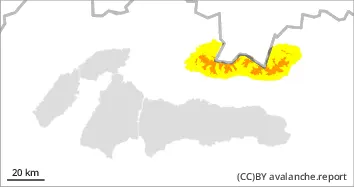
An undulating cold front associated with a pressure low centered over the Baltic Sea will advance into our area from the northwest. Cloudy to cloudy, gradually rain - also heavy. At night from about 1300 m, during the day gradually also at lower altitudes, snow. At first south-westerly, southerly wind. During the day it will change to predominantly northerly and in the AFTERNOON it will increase significantly and at high altitudes it will reach gale force! Significant cooling in the afternoon at all levels! The snow cover has been wet and damp in recent days so the cooling has hardened the snowpack. Up to 30 cm of new snow will fall on top of this hard and in places icy snow. Blizzards will cause it to be unevenly distributed. A continuous snow cover can be found from an altitude of 1200-1300 m above sea level.