In low altitudes the avalanche situation will be mainly influenced by rain, in high altitudes by wind and snow.
At altitudes up to 1400 m above sea level, the avalanche situation will be mainly influenced by rain in the forenoon. This will soak the snow cover, reducing its strength. Medium to large wet avalanches may occur. The second avalanche problem is new snow, which will mainly be added at altitudes above 1500 m, and in the afternoon at all altitudes. In total, around 10 cm of new snow is expected to be added during the day, accompanied by winds from northwesterly directions. On leeward E, SE and S slopes, winds together with new snow may produce snow slabs and cushions of smaller size.
Snowpack
dp.3: rain dp.6: cold, loose snow and wind
The snow cover will get wet and soft at altitudes up to 1500 m and will not be very suitable for skiing. New snow will be added at higher altitudes, but it will be transported to the south, southeast and east slopes and will therefore be very unevenly distributed. Overall, we do not recommend moving in the high mountains due to rain, poor visibility, high winds and snowfall.
Tendency
A frontal system will advance into central Europe in a strong northwesterly flow. Cloudy to cloudy and rain in several places, snow at altitudes from about 1300 m, snowing throughout the profile towards the evening. Mostly north-westerly wind 5 to 13 m/s, gusting to 16 to 23 m/s in places, 14 to 22 m/s at higher altitudes, gusting to around 33 m/s on ridges.
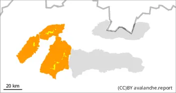
Danger level
1400m
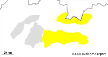
Avalanche Problem
New snow
1400m
Wet snow
1400m
The main avalanche problem is wet snow.
In low altitudes the avalanche situation will be mainly influenced by rain, in high altitudes by wind and snow.
At altitudes up to 1400 m above sea level, the avalanche situation will be mainly influenced by rain in the forenoon. This will soak the snow cover, reducing its strength. Medium to large wet avalanches may occur. The second avalanche problem is new snow, which will mainly be added at altitudes above 1500 m, and in the afternoon at all altitudes. In total, around 10 cm of new snow is expected to be added during the day, accompanied by winds from northwesterly directions. On leeward E, SE and S slopes, winds together with new snow may produce snow slabs and cushions of smaller size.
Snowpack
dp.3: rain dp.6: cold, loose snow and wind
The snow cover will get wet and soft at altitudes up to 1500 m and will not be very suitable for skiing. New snow will be added at higher altitudes, but it will be transported to the south, southeast and east slopes and will therefore be very unevenly distributed. Overall, we do not recommend moving in the high mountains due to rain, poor visibility, high winds and snowfall.
Tendency
A frontal system will advance into central Europe in a strong northwesterly flow. Cloudy to cloudy and rain in several places, snow at altitudes from about 1300 m, snowing throughout the profile towards the evening. Mostly north-westerly wind 5 to 13 m/s, gusting to 16 to 23 m/s in places, 14 to 22 m/s at higher altitudes, gusting to around 33 m/s on ridges.