Avalanches can be released especially on very steep slopes above 35°, with a large additional load (several skiers, jump, fall, movement on foot).
In general, however, the snow cover is fairly well stabilised. The main avalanche problem is wet snow. Temperatures above 0°C will soak the snow, which will disturb the stability of the snow. Rain will also have an impact and will occur in the afternoon at altitudes up to 1500 m above sea level. Avalanches or small wet spontaneous avalanches may occur on steep slopes. On the other hand, on northern and shady slopes, there may still be square-grained snow in the snow cover, which acts as a weak layer. The second avalanche problem is therefore a permanent weak layer.
Snowpack
dp.10: springtime scenario
The snow surface has been damp to wet during the last few days due to warming. At night the snow will harden and harden. It will soften again during the day and become wet, especially in the afternoon, when we expect light rain showers. Above 2000 m the snow will be hard and dry all day.
Tendency
A frontal system associated with a pressure low will advance into central Europe from the northwest. Cloudy to cloudy, with reduced cloud cover in the morning. Scattered, occasional rain in the afternoon in several places, snow from about 1500 m. Light gradually westerly wind 4 to 8 m/s in the foothills. From middle altitudes mainly westerly winds around 10, gradually 13 to 19 m/s.
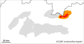
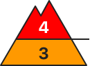
Danger level
1800m
Avalanche Problem
Persistent weak layer
1800m
Wet snow
The main avalanche problem is wet snow.
Avalanches can be released especially on very steep slopes above 35°, with a large additional load (several skiers, jump, fall, movement on foot).
In general, however, the snow cover is fairly well stabilised. The main avalanche problem is wet snow. Temperatures above 0°C will soak the snow, which will disturb the stability of the snow. Rain will also have an impact and will occur in the afternoon at altitudes up to 1500 m above sea level. Avalanches or small wet spontaneous avalanches may occur on steep slopes. On the other hand, on northern and shady slopes, there may still be square-grained snow in the snow cover, which acts as a weak layer. The second avalanche problem is therefore a permanent weak layer.
Snowpack
dp.10: springtime scenario
The snow surface has been damp to wet during the last few days due to warming. At night the snow will harden and harden. It will soften again during the day and become wet, especially in the afternoon, when we expect light rain showers. Above 2000 m the snow will be hard and dry all day.
Tendency
A frontal system associated with a pressure low will advance into central Europe from the northwest. Cloudy to cloudy, with reduced cloud cover in the morning. Scattered, occasional rain in the afternoon in several places, snow from about 1500 m. Light gradually westerly wind 4 to 8 m/s in the foothills. From middle altitudes mainly westerly winds around 10, gradually 13 to 19 m/s.
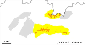
Danger level
Avalanche Problem
Wet snow
The main avalanche problem is wet snow.
Avalanches can be released especially on very steep slopes above 35°, with a large additional load (several skiers, jump, fall, movement on foot).
In general, however, the snow cover is fairly well stabilised. The main avalanche problem is wet snow. Temperatures above 0°C will soak the snow, which will disturb the stability of the snow. Rain will also have an impact and will occur in the afternoon at altitudes up to 1500 m above sea level. Avalanches or small wet spontaneous avalanches may occur on steep slopes. On the other hand, on northern and shady slopes, there may still be square-grained snow in the snow cover, which acts as a weak layer. The second avalanche problem is therefore a permanent weak layer.
Snowpack
dp.10: springtime scenario
The snow surface has been damp to wet during the last few days due to warming. At night the snow will harden and harden. It will soften again during the day and become wet, especially in the afternoon, when we expect light rain showers. Above 2000 m the snow will be hard and dry all day.
Tendency
A frontal system associated with a pressure low will advance into central Europe from the northwest. Cloudy to cloudy, with reduced cloud cover in the morning. Scattered, occasional rain in the afternoon in several places, snow from about 1500 m. Light gradually westerly wind 4 to 8 m/s in the foothills. From middle altitudes mainly westerly winds around 10, gradually 13 to 19 m/s.