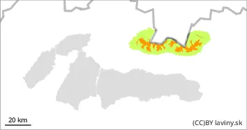
Increasing tendency during the day, watch out for more new, wind-drifted snow on steep slopes and in gullies!
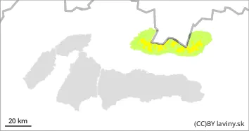
Due to unstable snowfall during Thursday and Friday, the avalanche danger in the High and Western Tatras will increase to level 3 in the afternoon. Avalanche release is possible on steep slopes with only a small additional load. Smaller spontaneous avalanches from new snow are also possible.
Snowpack
A total of 15 to 30 cm of new snow is expected to fall during Thursday and Friday, which will be transported to leeward locations of predominantly southerly orientations during the day as winds pick up. The wind-drifted snow will create unstable snow slabs, pillows and drifts.
Tendency
increasing during Friday, persisting on Saturday.
Danger level
treeline
Avalanche Problem
New snow
Treeline
Wind slab
Treeline
Watch out for more new, wind-drifted snow on steep slopes and in gullies!
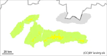
Due to intense snowfall (1-2 days) a moderate avalanche danger, 2nd degree, has been created in the Low Tatras and Fatras. Avalanche release is possible on steep slopes, especially at higher additional loads. Occasionally, smaller spontaneous avalanches from new snow are possible.
Snowpack
During Thursday and the following night, 10 to 20 cm of new snow is expected, locally even more. The new snow will be transported to the leeward slopes, into couloirs and under saddles, mainly in the south, southeast and southwest orientations, where it will form unstable snow slabs, cushions and overhangs. The new dry snow is insufficiently bonded to the old snow cover and is therefore susceptible to avalanche.