Watch out for wet snow in the afternoon and weak layers on northerly orientations
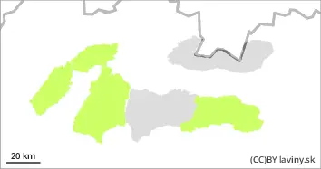
Moderate avalanche danger (2nd degree) is valid in the High and Western and western part of the Low Tatras. A typical spring situation prevails. The snow hardens at night and melts during the day. The main avalanche problem is therefore wet snow up to 2100 m above sea level. On the northern side of the highest altitudes there is still a permanently weak layer in the snow profile. The current situation on the ground requires good decisions, avoid steep places, watch out for a larger layer of melted snow, but also avoid places where blown snow from the last snowfall is evident and has not fallen with an avalanche in the previous days.
Snowpack
The very warm spring weather continues. Temperatures are reaching positive numbers at altitudes below 2100 m a.s.l. Snow is hardening at night and then softening again during the day. On the northern side of the mountains, in shaded areas, the snow still retains its powdery character. At the highest points (above 2100 m), there is a permanently weak layer of square-grained snow on the northern side of the mountains. The snow cover remains well below average, especially at altitudes below 1500 m above sea level.
Tendency
Permalink
AM Danger level
PM Danger level
treeline
Avalanche Problem
Wet snow
Treeline
Beware of avalanches and avalanches from wet snow
In the Fatras and in the eastern part of the Low Tatras a low avalanche danger (1st degree) is declared above the forest zone. Due to warming and subsequent night freezing, the situation is stabilizing. The main problem is wet snow. The avalanche situation requires good decisions, avoid steep slopes, watch out for a larger layer of melted firn, but also avoid places where the blown snow from the last snowfall is evident and did not fall with the avalanche in the previous days.
Snowpack
Temperatures will also reach positive numbers at the highest altitudes. Warm weather in the afternoon is causing the snow cover to become wetter and the cohesion of individual layers to decrease. The snow cover remains well below average, especially at altitudes up to 1500 m above sea level.