Watch out for snow pillows and slab snow on the leeward (N-SW) sides of the mountains. Wet to wet snow at altitudes up to 1600 m!
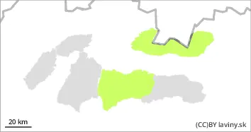
In the High, Western and central part of the Low Tatras there is a SMALL avalanche danger (1st degree of the 5-part scale). With the exception of isolated slopes, especially N and NW exposures, generally a favourable avalanche situation prevails. Avalanche release is possible on very steep slopes where snow slabs and pillows are deposited, especially with high additional loads. Avalanches and small avalanches from wet snow are possible at altitudes up to 1600 m above sea level.
Snowpack
Snow from the last snowfall was blown by strong winds onto the leeward slopes or into valleys, the windward sides and ridges are often blown down to grassy or rocky ground. In most positions, a crust or layer of hard firn is formed on the surface of the snow cover. On the northern slopes above 1800 m above sea level there is mostly dry snow of varying quality, in places loose, but most often wind-bound in the form of snow slabs or pillows. As the day warms up, the snow cover at altitudes up to 1600 m will be moist to wet. Overall snow cover remains below average.
Tendency
with snowfall expected from Sunday to Monday, rising
Danger level
Avalanche Problem
Wet snow
Generally favourable avalanche situation, beware of isolated steep slopes with wet snow!
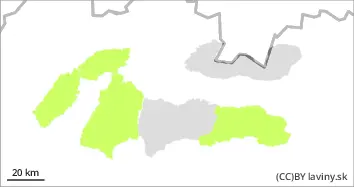
In the Fatras and the eastern part of the Low Tatras there is only a SMALL avalanche danger (1st degree of the 5-part scale). The snow cover is stabilized, the occurrence of spontaneous avalanches is not expected. On isolated steep slopes, where more snow is piled up, smaller avalanches are possible when it gets warmer during the day, especially with large additional loads.
Snowpack
Snow from the last snowfall period has been blown by strong winds into the valleys, the windward sides and ridges are often blown down to the grassy base. At most elevations, a crust or layer of hard firn has formed on the surface of the snow cover, with new wet snow accumulating in places. The overall snow cover is still well below average.
Tendency
with snowfall expected from Sunday to Monday, rising