Danger level
 |
|  |  |

![]()
A persistent inversion is causing warm weather even at the highest elevations, watch out for wet snow.
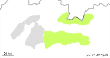
In all mountain ranges where there is still a continuous snow cover (High, Low, Western Tatras) there is a low avalanche danger. The snow cover has stabilised due to temperature changes. Due to the inversion, high temperatures persist even at the highest altitudes, causing wet snow during the day. Spontaneous wet avalanches from warming temperatures may occur, especially in the afternoon as cloud cover gradually decreases.
Snowpack
The weather during Thursday will be influenced by the edge of a pressure high, bringing a gradual decrease in cloud cover and still very high temperatures for December. The weather pattern of the last few days has caused daytime heating and overnight freezing of the snow cover. This has resulted in a hard firn and frozen snow cover surface that is well consolidated and stable. It may gradually soften during the day. A continuous snow cover occurs in the Low Tatras from an altitude of about 1200 m and reaches 50 to 80 cm at the highest altitudes. In the Western and High Tatras there is snow from about 1500 m above sea level and its height is only up to 50 cm.