The danger is fresh, wind-drifted snow deposited in the form of wind slabs and pillows.
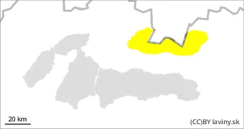
In the high altitudes of the Western and High Tatras (above 1700 m above sea level) the avalanche danger increases from 2nd to 3rd degree - CONSIDERABLE, due to snowfall and strong wind during the day. Snowfall accompanied by extremely strong northerly wind creates dangerous snow slabs and pillows of varying thickness. Their distribution is very local - depending on the relief and the prevailing wind direction. Often under saddles, rock walls and in leeward troughs, where new snow reaches more than 50 cm. Avalanche release on steep slopes is possible with only a small additional load. Occasional spontaneous medium-sized avalanches are possible.
Snowpack
The weather and snow cover changed significantly after a period of warm weather due to a strong cooling. Winter conditions prevail in the mountains and the air temperature has dropped to -10 to -20 °C. Between 15 and 30 cm of new snow will fall during the night from Saturday to Sunday + Sunday, but accompanied by extremely strong winds of 25 m/s, gusting up to 35 m/s. Older snow will freeze as a stone, and new snow of varying thickness will be on the surface - depending on wind and relief. At altitudes up to 1600 m there is almost no older snow under the new snow.
Tendency
Rising during the day during snowfall.
Danger level
1700m
Avalanche Problem
Wind slab
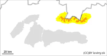
1700m
Watch out for localised, wind-slabs and pillows.
In the Low Tatras at altitudes above 1700 m above sea level there is a low avalanche danger (1st degree). Unstable snow slabs and pillows from the current snowfall occur locally - especially under saddles, rock walls, in moguls and steep couloirs.
Snowpack
The weather and snow cover changed significantly after a period of warm weather due to a strong cooling. Winter conditions prevail in the mountains. Up to 10 cm of new snow will fall during the night from Saturday to Sunday + on Sunday, but accompanied by extremely strong winds of 25 m/s, gusting up to 35 m/s. Older snow will freeze to stone, and new snow of varying thickness will be on the surface - depending on wind and relief. At altitudes up to 1600 m above sea level, there is only patchy snow cover.