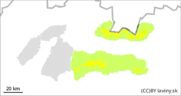
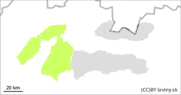
In the High, Western and Low Tatras above the forest line a moderate avalanche danger (2nd degree) is declared. The weather will be influenced by warm air inflow during Friday, however, we expect clouds during Friday, so the melting of snow on the south slopes will not be so pronounced. On S-facing slopes, it's still possible to find patches of dry, untracked snow lying on top of a layer of ice or old hardened snow, with a dangerous layer of square-grained snow in between. Avalanches are expected to be triggered mainly on steep to very steep terrain, especially with high additional loads. Stability is very difficult to assess on S slopes, the most dangerous are places with visibly blown snow, on S slopes it is necessary to note the soaked snow layer. During the day, spontaneous avalanches and avalanches of wet snow can also occur on the S slopes. Only small or medium avalanches are to be expected, but the problem is the transport and accumulation zone of the deposits, where, due to the low snow cover, there is often rock debris or exposed rock blocks.
Snowpack
The snow cover is below average, with continuous snow cover above 1600 m above sea level. At the S exposures, crust or firn has formed on the surface of the snow cover. On the S exposures of the highest exposures, the snow still retains a powdery character, under which a permanently weak layer of square-grained snow persists. Snow cover is expected to melt during the day on S exposures.
Tendency
The avalanche hazard trend is persistent.
Danger level
treeline
Avalanche Problem
Wet snow
Treeline
Prolonged warming at the highest altitudes. Watch out for wet snow
A low avalanche danger (1st degree) has been declared for Malá and Veľká Fatra. In general, the snow from the last snowfall has melted and a layer of crust or firn has formed on its surface due to the change in temperature. On the S-facing slopes it is still possible to find very localised patches of dry, untreated snow on top of a layer of ice or old hardened snow. During Friday, the weather in the mountains of Slovakia will continue to be influenced by an influx of very warm air, but unlike the previous days, clouds are also expected, so the snow accumulation will not be as significant as during Thursday. Avalanches are expected to occur mainly on steep to very steep terrain, especially with high additional loads, especially on south-facing slopes, where spontaneous avalanches and drifts of wet snow may also occur. Only small or medium avalanches are to be expected, but the problem is the transport and accumulation zone of the deposits, where, due to the low snow cover, there is often rock debris or exposed rock blocks.
Snowpack
The snow cover is below average, with continuous snow cover above 1500 m above sea level. The snow from the last snowfall period has settled and turned into crust or firn. It retains its powdery character on the isolated S-facing slopes of the highest altitudes. Snow cover is expected to melt during the day, especially on S exposures.