The caution to the north is still a permanently weak layer. Wet snow in the south.
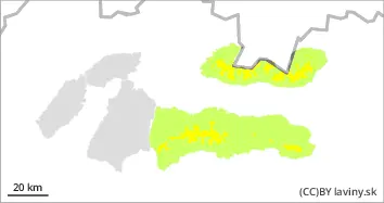
In the High, West and Low Tatras above the forest line a moderate avalanche danger (2nd degree) is declared. In general, the snow from the last snowfall period (Thursday-Saturday) has melted and a layer of crust or firn has formed on its surface on the southern exposures due to temperature changes. On the S facing slopes it is still possible to find places with dry untreated snow lying on a layer of ice or old hardened snow, between which there is a dangerous layer of square-grained snow. During Thursday, the weather in the mountains of Slovakia will be influenced by a pressure high, which will bring clear and very warm weather. On S-facing exposures, the snow cover will be progressively sun-soaked during the day. Avalanche release is expected mainly on steep to very steep terrain, especially with high additional loads. Stability is very difficult to assess on S slopes, the most dangerous places are those with visibly blown snow, and on S slopes it is important to note the waterlogged snow layer. During the day, spontaneous avalanches and avalanches of wet snow can also occur on the S slopes. Only small or medium avalanches are to be expected, but the problem is the transport and accumulation zone of the deposits, where, due to the low snow cover, there is often rock debris or exposed rock blocks.
Snowpack
The snow cover is still below average, with continuous snow cover above 1500 m above sea level. During the last snowfall period, up to 30 cm of new snow fell, which gradually settled and turned into crust or firn on the S exposures. However, on the S exposures of the highest elevations, this snow still retains a powdery character, under which persists a permanently weak layer of square-grained snow. Snowpack is expected to melt during the day on S exposures.
Tendency
Rising during the day, falling towards evening, generally persistent.
bl
AM Danger level
treeline
Avalanche Problem
Wet snow
Treeline
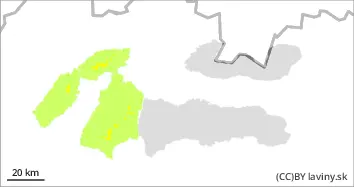
PM Danger level
treeline
Avalanche Problem
Wet snow
Treeline
Watch out for snow cover melting during the day.
Moderate avalanche danger (2nd degree) has been declared for Malá and Veľká Fatra since noon. In general, the snow from the last snowfall (Thursday-Saturday) has melted and due to the change in temperature a layer of crust or firn has formed on its surface. On the S-facing slopes it is still possible to find occasional local patches of dry, untreated snow lying on top of a layer of ice or old hardened snow. During Thursday, the weather in the mountains of Slovakia will be influenced by a pressure high, which will bring clear very warm weather. On S facing exposures, the snow cover will be progressively sun-soaked during the day. Avalanches are expected to be released mainly on steep to very steep terrain, especially under high additional loads, especially on S slopes where spontaneous avalanches and drifts of wet snow may also occur. Only small or medium avalanches are to be expected, but the problem is the transport and accumulation zone of the deposits, where, due to the low snow cover, there is often rock debris or exposed rock blocks.
Snowpack
The snow cover is still below average, with continuous snow cover above 1500 m above sea level. During the last snowfall period, up to 30 cm of new snow fell, which gradually settled and turned into crust or firn. It retains its powdery character on the N-facing slopes of the highest altitudes. Significant snow cover is expected to melt during the day on S exposures.
Tendency
Rising during the day, falling towards evening, generally persistent.