Watch out for wet avalanches on steep slopes in the morning. In the afternoon, cooling from the west and snowing above the treeline!
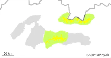
In the High, Western and Low Tatras above the 1700 m above sea level there is a MODERATE avalanche danger (2nd degree). In the previous days 15 to 30 cm of new snow fell in the region, which is unevenly distributed. Due to the current short-term warming, smaller spontaneous avalanches from wet snow are possible. Avalanche release is also possible with higher additional loads, especially on very steep slopes. In the afternoon, as the snowfall increases, avalanches will be possible in places with more new snow, which will be transported locally to leeward places.
Snowpack
The snow cover above the tree line, depending on the altitude, is made up of new snow ranging from 5 to 30 cm thick. The new snow is already mostly set, and will be wet to wet in the morning at middle altitudes. Further snowfall is expected in the afternoon, with the snowline decreasing from 1600 to 1200 m above sea level as it gradually cools.
Tendency
persistent during the day
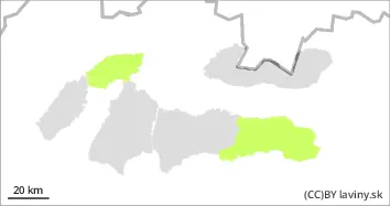
Danger level
1400m
Avalanche Problem
Wet snow
1400m
Beware of very steep slopes with wet snow in connection with terrain traps.
In the eastern part of the Low Tatras and in Krivanská Mala Fatra there is only a SMALL avalanche danger (1st degree). The avalanche problem is wet snow in all orientations. In narrow couloirs and under rock walls locally there may be a large amount of new snow. Its release is possible with large additional loads on very steep slopes. Smaller spontaneous avalanches of wet snow may also occur as the day warms up.
Snowpack
During the last snowfall period, between 5 and 20 cm of new snow fell at the highest altitudes. However, it is unevenly distributed due to the previous strong winds. During the day, as the weather warms up, the snow cover will be wet and its total height will decrease at altitudes up to 1500 m above sea level.