Watch out for new wind-blown snow at the highest elevations and wet snow in the mid-elevations!
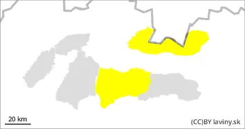
The weather during Tuesday will be influenced by a frontal boundary and a pressure low advancing from the southeast. The latter will bring precipitation, which will be rainy up to 1700 m above sea level. In the High, Western and Western part of the Low Tatras there is a moderate avalanche danger, i.e. the second degree of the 5-part international scale. At the highest altitudes, the main avalanche problem is wind-blown snow, especially in the N, NW, NE and W orientations. Thus, in the gullies of the highest altitudes with a high slope, situated on the leeward sides of the ridges, it is possible to find wind-rolled slabs and pillows of unstable snow, which can be loosened, especially by large additional loads. At mid-elevations, rain reduces stability by intensively soaking the snow cover, so the second avalanche problem is wet snow. Avalanches from wet snow or foundation avalanches from wet snow can occur, especially on slopes with visible crevasses.
Snowpack
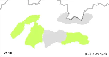
The warm February weather has meant that snow cover is absent at lower elevations. Above it, there is a firn snow cover in the mid-altitudes, which is, however, intensively waterlogged by rain and positive temperatures. Gullies have formed in a number of places, triggering basal avalanches in many places. This situation will persist for the next few days. Dry snow is only found at the highest elevations of the mountains and has been transported by the wind to the leeward sides of the mountains in slabs and pillows. Such formations lie on a layer of old firn with which they are not sufficiently bound.
Tendency
Danger level
Avalanche Problem
Wet snow
Gliding snow
Beware of wet snow on all orientations.
In the Fatras and the eastern part of the Low Tatras there is still a small avalanche danger. The weather during Tuesday will be influenced by a frontal boundary and a pressure low advancing from the southeast. The latter will bring precipitation, which will be rainy up to 1700 m above sea level. Rain and warm weather will continue to reduce stability by intensively drenching the snow cover, so wet snow and slippery snow are the main avalanche problems. Wet snow avalanches or foundation avalanches from wet snow may occur, especially on slopes with visible gullies. Very steep couloirs with higher snow depths or significant avalanche paths will be dangerous.
Snowpack
The warm February weather has meant that snow cover is absent at lower elevations. Above it, there is a firn snow cover in the mid-altitude troughs and at the highest altitudes, but it is heavily waterlogged by rain and positive temperatures. Blowouts have formed in several places, triggering foundation avalanches in many places. This situation will persist for the next few days.
Tendency
The impact of the still warm weather has persisted.