Overhanging snow slabs at the highest elevations, possible wet avalanches in the afternoon after warming up.
In the High, Low and Western Tatras there is a moderate avalanche danger at altitudes above 1700 m a.s.l. Winds from northern directions have created snow slabs and pillows on the southern leeward slopes. Avalanche release is possible here, especially with high additional loads. In the lower altitudes it had mainly rained in the previous days, therefore after the subsequent cooling the snow hardened and stabilised. In the afternoon, after warming up, the snow will soften to about 1800 m a.s.l. Wet snow will be an avalanche problem. Small spontaneous avalanches may occur.
Snowpack
At high altitudes, snow slabs and pillows are found on the hard ground in places. Underneath is mostly hard rain crust. Continuous snow cover occurs from about 1200 m a.s.l. The snow will soften in the afternoon due to warming.
Tendency
With warming slightly rising.
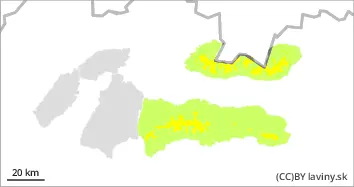
AM Danger level
PM Danger level
1300m
Avalanche Problem
Wet snow
1300m
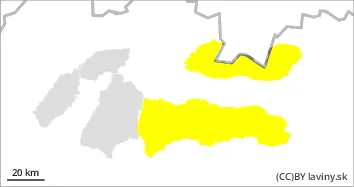
Stable avalanche situation in the morning. In the afternoon with warming wet avalanches.
In Mala and Velika Fatra in the morning stable situation, low avalanche danger (1.degree). In the afternoon, due to warming, the snow cover will get wet, which will reduce its cohesion, therefore the avalanche danger will increase to 2nd degree (moderate). Wet avalanches will be an avalanche problem. At altitudes below 1300 m there is only incoherent snow cover, so avalanches are not expected there.
Snowpack
The snow cover is hard to icy in the morning, but by midday we expect it to become wet and soft due to warming. Continuous snow cover occurs from about 1200 m above sea level.