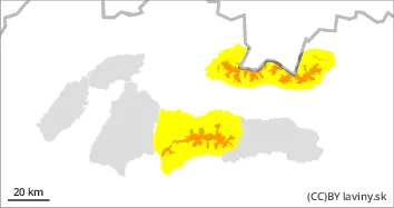
For the High Tatras, the Western Tatras and the western part of the Low Tatras there is an increased avalanche danger above the 1500 m above sea level, i.e. 3 degree from the five-part international scale. This danger is due to the progression of the frontal system and moist warm air, which will bring heavy precipitation at high altitudes associated with extremely strong winds. The main avalanche problem is thus new snow (above 1500 m above sea level) and wind-blown snow (in E, SE, S and SW orientations). During the day, wind will intensively transport snow to the leeward slopes of the mountains, where it will create unstable pillows and slabs of packed snow, even on lower slopes. The third avalanche problem below 1500 m is wet snow. Avalanche release will be possible with only a small additional load. Spontaneous avalanches are also expected during the day, especially immediately after the snowfall, which may be up to medium-sized.
Snowpack
The old snow cover melted and froze due to the weekend warming and subsequent cooling. A thick crust of icy snow has formed on the surface. At high altitudes, new precipitation will be intensively blown by strong winds to the leeward sides of the mountains. Here, snow pillows and slabs of wind-blown new snow will form, lying on top of the old hardened cover. There will be a large difference in the hardness of the layers between these layers, and the snow slabs will be very fragile due to the beating of the wind, which will cause instability. Snow is expected to continue to accumulate at the highest altitudes during the day. From the mid-altitudes downwards, the precipitation is of a rain nature, which is why the snow cover here is waterlogged.
Tendency
With precipitation and winds forecast to increase.
Danger level
1400m
Avalanche Problem
Wind slab
1400m
Wet snow
1400m
For the Fatra Mountains and the eastern part of the Low Tatras there is a moderate avalanche danger, i.e. 2 degree from the five-part international scale. This danger is due to the progression of the frontal system and moist warm air, which will bring heavy precipitation at high altitudes associated with extremely strong winds. The main avalanche problem at the highest altitudes is wind-blown snow (in E, SE, S and SW orientations) and wet snow (below 1500 m). High snowfall thresholds mean that intensive snow cover growth is not predicted for these regions. However, intense rain during the day will have a destabilising effect on the snow profile.
Snowpack
The old snow cover melted and froze due to the weekend warming and subsequent cooling. A thick crust of icy snow has formed on the surface. Snowfall is expected only at the highest elevations of these mountains, where the wind blows it to the leeward sides of the mountains. Here there are snow pillows and slabs of wind-blown new snow lying on top of the old hardened cover. Overall, the snow cover has become sooty and wet as a result of the warming. Precipitation is expected to continue during the day and, with the exception of the highest elevations, the snow cover will be soaked.