Danger level
 | treeline |
|  |
|  | ||||
|  |  |


![]()
High winds with significant precipitation will cause unstable slabs of wind-drifted snow that are deposited on hard ground.
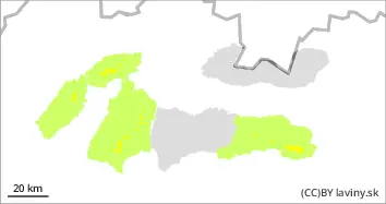
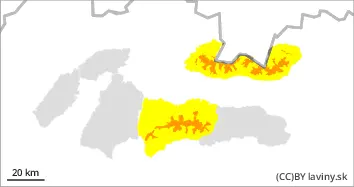
In the Western, High and Western part of the Low Tatras there is an increased avalanche danger above the forest boundary, i.e. the 3rd degree. The main avalanche problem remains wind-blown snow. Strong north-westerly winds will reach speeds of 45-50 m/s (160-180 km/h) on Saturday. It will produce hard wind-beaten slabs in which stresses will propagate well. There is also a critical layer of crusts in the snow profile from Thursday's snowfall. Particularly dangerous are leeward sides of ridges, areas under glass walls and narrow couloirs. Particularly dangerous are the exposures of the S, SE, SW and E orientations. Avalanches can be released with only a small additional load, especially on steep slopes. In some cases, medium avalanches, exceptionally also large spontaneous avalanches are possible. Mountain terrain is not recommended for inexperienced hikers/ski mountaineers.
Snowpack
In the last 24 hours the most snow fell in the Western and High Tatras up to 30cm. During Saturday, new snow is expected up to 30cm. However, this will be very unevenly distributed due to strong winds. Mountain ridges will be blown into hard ground. On the leeward slopes and in places where the wind speed is lower, the new snow will be deposited in pillows and slabs of varying hardness. In the forest belt there will be mainly loose powder snow. Despite the snowfall in recent days, the snow cover is well below average at altitudes up to 1200 m above sea level.
Tendency
Significantly rising due to strong winds and expected precipitation.
Compiled By : Pavel Beťko