Danger level
 |
|  |  | |||||
|  |
| |


![]()
New wind-driven snow and gradual warming
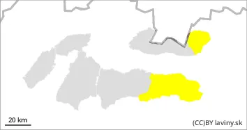
For the Fatras and the West of the Tatras and the Low Tatras is declared the 3rd degree of avalanche danger (increased danger) from the 5-point international scale. In these mountain ranges, 40 to 70 cm of new snow has fallen in the forest zone, and further snowfall is forecast with gradual warming. At higher altitudes, there is less new snow, blown into leeward troughs and moulds and into the slash and forest zone. The layers of new snow are deposited on a hard frozen surface, which is a good sliding surface. Watch for thick pillows of blown snow in easterly orientations. Mechanical release of avalanches is likely to be possible on steep slopes with little additional loading. Moderate-sized spontaneous avalanches are likely to occur in the current warming period.
Snowpack
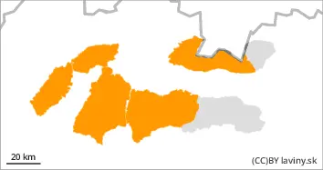
A warm front is advancing in the westerly flow. It will bring, in addition to more snow (with continued westerly winds), warming. During this period of snowfall, since Thursday, 40 to 70 cm of new snow has already been added in the marked area, in the forest zone. Strong north-westerly winds are transporting the new loose snow to lower elevations, into the forest and slash zone. At high altitudes, we are generally seeing only a few tens of cm of new snow. In some places it is blown down to the old hard base. The snow is unevenly distributed due to the wind. Dangerous snow pillows more than 1 m thick are forming on leeward slopes, in gullies and moguls of mainly easterly orientations. Warming will reduce the strength of the new snow layers,
Tendency
With the gradual warming, the avalanche danger tends to increase slightly.
Compiled by Ivan Chlebovec