Danger level
 |
|  |  |

New snow blown by the wind
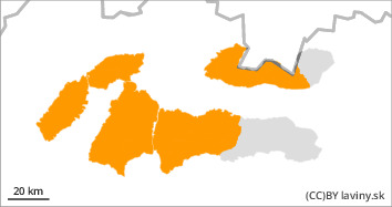
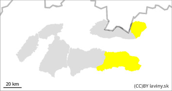
For the Fatras and the West of the Tatras and the Low Tatras is declared the 3rd degree of avalanche danger (increased danger) from the 5-part international scale. Between 30 and 50 new snowfalls have fallen in these mountain ranges, and snow showers are forecast to bring another 20cm of snow. A layer of new snow is being deposited on an already hard frozen surface, which is a good sliding surface. At the same time, the new snow is being transported into the leeward gullies and moulds of a predominantly easterly orientation, where dangerous snow pillows and slabs are forming. Mechanical release of avalanches is likely to be possible on steep slopes with little additional loading.
Snowpack
Snow showers, mainly in the form of showers, arrive in a cold and moist flow from the northwest. In the Fatras and the Low Tatras 30-40cm of new snow was added by Friday afternoon. In the western part of the Tatras, more than 50cm in places. At the same time, strong westerly to north-westerly winds are blowing in the mountains, carrying new loose snow to the lower altitudes, to the forest and slash and scrub zone. Dangerous snow pillows and slabs are forming on leeward slopes, in couloirs and couloirs of predominantly easterly orientations.
Tendency
With snow and strong winds, avalanche danger is increasing in all mountain ranges.
Compiled by Ivan Chlebovec


