Beware of wind-blown snow at the highest altitudes!
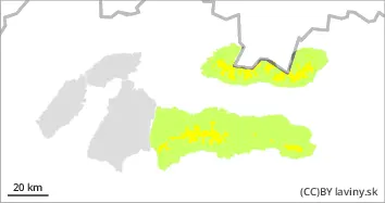
In the highest altitudes (above 1700 m) of the High, Western and Low Tatras there is still a moderate avalanche danger (2nd degree from the 5-part international scale). The danger is mainly posed by the leeward sides of ridges and steep to extremely steep couloirs (above 35°) of the highest altitudes, where strong winds of recent days have transported large amounts of snow. Snow pillows and slabs are found in these places, the stability of which is difficult to assess. Their loosening is possible with high additional loads (e.g. walking, falling). At lower altitudes, small spontaneous avalanches of wet snow can occur due to warming and rainfall. The avalanche danger increases with altitude, and medium-sized avalanches may occur at altitudes above 1700 m above sea level.
Snowpack
The most snow is found in the High, Western and Low Tatras, where the average snow cover from the middle positions reaches from 40 to 80 cm. The snow cover is very unevenly distributed due to the wind, on the windward sides it is blown down to the substrate, on the leeward sides there are snow pillows and slabs of unbound snow.
Tendency
It persisted through Tuesday, and conditions are expected to cool and freeze and stabilize by Wednesday.
Danger level
Avalanche Problem
Wet snow
In the Fatras there is a low avalanche danger, i.e. the first degree of the 5-part international scale. Gradual warming and expected rainfall will cause the snow cover to become wet throughout the profile. Smaller avalanches from wet snow and small foundation avalanches may occur sporadically.
Snowpack
The snow cover in the Fatras ranges from 10 to 30 cm of snow. The ridges are blown into the hard ground. At lower altitudes below 1300 m above sea level, there is no continuous snow cover yet. Tomorrow's warmer temperatures will cause the snow cover to become wet throughout the whole profile and will break through to the subsoil.
Tendency
It persisted through Tuesday, and conditions are expected to cool and freeze and stabilize by Wednesday.