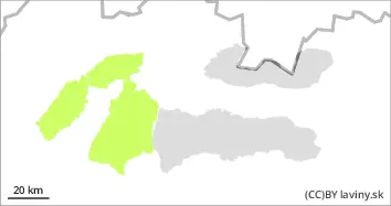
Danger level
 | 1600m |
|  |
|  | ||||
|  |
| |

![]()
Beware of wind-blown snow in the form of snow pillows and slabs!
In the High, Western and Low Tatras there is still a 2nd degree of avalanche danger from 1600 m above sea level. Strong mainly northwest winds have transported large amounts of snow since yesterday. Especially dangerous are leeward sides of ridges, steep couloirs (above 35°) and places under rocks. Especially in these places there are snow pillows and slabs, the stability of which is difficult to estimate. Their loosening is possible with high additional loads (e.g. on foot). The avalanche danger increases with altitude at 1600 m a.s.l. Even medium-sized avalanches can occur.
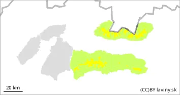
Snowpack
dp.4: cold following warm / warm following cold
During the last snowfall, between 10 and 25 cm of new snow fell on the mountains. In total, snow depths have reached up to 100 cm in places. As it is only the beginning of the season, there are mostly only 3 layers of snow in the snow cover, but they are not well interconnected. The new snow is unevenly distributed due to strong winds and deposited in terrain depressions and on the leeward sides of ridges. The snow cover is not load-bearing and is worn down to the subsoil. A continuous layer of snow cover can be found from about 1500 m above sea level.
Tendency
During the day the snow cover will stabilise slightly due to warming.