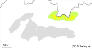
Moderate avalanche danger is declared in the High and Western Tatras, 2nd degree. The avalanche problem is wind-blown snow from the last snowfall. More than 30 cm of it fell last week, mainly on the northern side of the Tatras. The situation has been complicated by the wind, which has created dangerous snow slabs and pillows. Avalanches are possible on steep slopes, especially with high additional loads. On the southern slopes the situation is stable after the warm weather and the subsequent cooling. The cooling will continue, so the wet snow will freeze and harden even more.
Snowpack
More than 30 cm of new snow has been added in the last snowfall period. On sunny slopes, the snow got wet and then froze, which stabilised the situation. Dry snow can now only be found at high altitudes on shady and northern slopes. Continuous snow cover can be found at altitudes above 1300-1500 m above sea level, depending on orientation.
Tendency
decreasing with cooling
Danger level
1300m
Avalanche Problem
Wet snow
1300m
Watch out for wet snow!
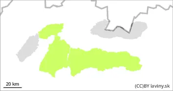
In the Fatras and Low Tatras a low avalanche danger (1st degree) is declared above the forest zone. Up to 20 cm of new snow has fallen during the last snowfall period, which has become wet due to warming. Gradually, as it gets colder, it will harden and freeze. In several places the new snow has already melted completely. Avalanche release is only possible at the highest altitudes on very steep slopes with high additional loads. Occasionally, only small spontaneous wet avalanches are possible.
Snowpack
About 20 cm of snow has been added during the last snowfall period, but the warm weather has meant that the new snow has almost completely melted. Overall, the snow cover is below average.