Beware of wind-drifted snow on windward slopes and in couloirs!
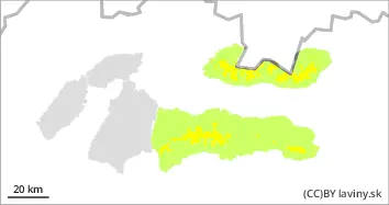
In the High, Western and Low Tatras there is a MODERATE avalanche danger, 2nd degree. Avalanche release is possible on steep slopes, especially at higher additional loads. Spontaneous avalanches from wet snow are also possible on southern slopes at middle altitudes.
Snowpack
During the last significant snowfall (Thursday - Friday), 25 to 40 cm of new snow fell. This was blown by very strong winds to leeward places, mainly in southerly orientations, where it created unstable snow slabs, pillows and drifts. As a result of Saturday's warming and subsequent cooling, the snow cover has settled relatively quickly and is stabilising. The snow will be wet to wet up to 1600 m above sea level, and will remain dry at the highest elevations. Continuous snow cover will be found above 1200-1500 m depending on orientation.
Tendency
With precipitation expected during Tuesday >> INCREASING
fk
Danger level
treeline
Avalanche Problem
Wet snow
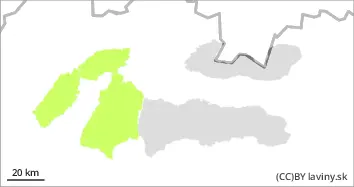
Treeline
Watch out for wet snow when it warms up during the day!
Avalanche release is only possible at the highest altitudes of the Fatra Mountains on very steep slopes with higher additional loads. Occasionally, smaller spontaneous avalanches from newer wet snow are possible.
Snowpack
During the last snowfall (Thursday-Friday) 10-20 cm of new snow fell, but it has largely melted. More snow remained at the highest altitudes, especially in the couloirs and under the saddles of the south, southeast and southwest orientations. On the southern, sunlit slopes the snow will soften considerably during the day.