Beware of wind-blown snow on hard ground and a permanently weak layer on the northern sector at the highest altitudes!
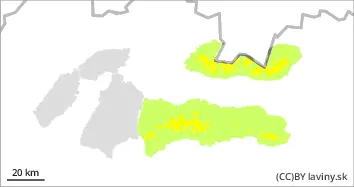
In the High, Western and Low Tatras there is a moderate avalanche danger above 1700 m above sea level, i.e. 2nd degree. Here, due to snowfall and strong winds in the previous days, unstable snow slabs and pillows have formed, especially in the northern orientations. The new snow and wind-blown slabs are deposited on the old hard base, with which it is not sufficiently bonded. In the northern sector, there is also an unstable layer of square-grained snow in the snow profile at the highest elevations. u Avalanche can be released in steep and very steep terrain. Occasional smaller spontaneous avalanches are possible.
Snowpack
During Friday we expect partly cloudy weather, occasional showers, snow from 1300 m above sea level. Older snow cover is mostly well consolidated and settled, except in the northern sector of the highest elevations where unstable snow types are present in the profile. Between 10 and 20 cm of new snow has fallen on the hardened base in recent days. This is unevenly distributed, especially in the northern sector. Hard slabs alternate with puffy pillows of new snow. On the ridges, overhangs have formed. Snow cover remains well below average, especially at altitudes up to 1600 m above sea level.
Tendency
With the weather forecast to persist through Friday, decreasing slightly with the arrival of the cooler temperatures overnight Friday into Saturday
Danger level
Avalanche Problem
Wet snow
Avalanche release is possible only sporadically on very steep slopes.
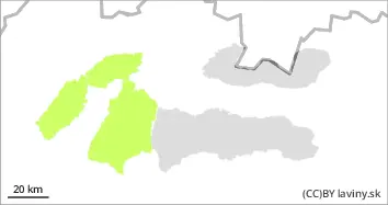
In the Fatras and the eastern part of the Low Tatras there is still a small avalanche danger, 1.degree. Up to 10 cm of new snow has fallen above the forest border, which lies on hard ground and is not sufficiently well connected. For the second day, a warming trend, which has brought the 0°C isotherm up to the highest altitudes, will cause the snow to become heavier. Smaller avalanches can only be released exceptionally, and only on steep and very steep slopes, with the risk of pushing a person into exposed terrain.
Snowpack
During Friday we expect partly cloudy weather, occasional showers, snow from 1300 m above sea level. Older snow cover is mostly well consolidated and settled . The snow surface consists of 10-20 cm of new snow from the last snowfall, lying on top of an older hard base. Due to the high 0°C isotherm, this snow will become wet and heavy. The total snow cover is well below average, mostly less than 50 cm. In gullies and moguls in isolated places even more, on the ridge there are overhangs due to the wind.