Watch for snow pillows on the leeward (V) sides of the mountains and snow accumulation during the day.
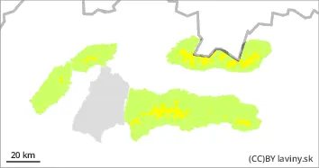
In the High , Western, Low Tatras and Mala Fatra Mountains there is a MODERATE avalanche danger above the forest line (i.e. 2nd degree of the 5-part scale). Significant snowfalls from the weekend were often blown by strong winds up to the forest zone. However, on the leeward sides of the mountains (especially SE and E), winds have locally created snow pillows and slabs, the stability of which may be low, especially on steep to very steep slopes. Avalanches can be released locally, especially by large additional loads. The snow will gradually become heavier as the weather warms up, especially at middle altitudes, and small spontaneous avalanches may occur sporadically during the day, mainly from wet snow.
Snowpack
The weather during Wednesday will be influenced by a weak cold front and an influx of warm air. The 0°C isotherm will gradually reach the mid to high teens. Snow is very unevenly distributed across the terrain. The strong winds of the last few days have blown it to the SE and E sides of the mountains, while the windward sides of the mountains will be blown onto the hard underlying firn layer or up to the soil surface. During the day the snow will be heaved and set due to warming. Overall snow cover is still below average, with improved conditions at low elevations.
Tendency
Slightly decreasing
Danger level
Avalanche Problem
Wet snow
Watch for snow pillows on the leeward (V) sides of the mountains and snow accumulation during the day.
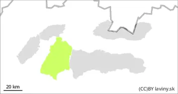
In Veľká Fatra there is a SMALL avalanche danger (i.e. 1st degree of the 5-point scale). The snow accumulation during the weekend snowfall was not that significant here. The new snow here was often blown by strong winds into the forest zone. On the leeward sides of very steep slopes (mainly SE and E) it can occasionally be found deposited in smaller snow pillows and slabs, the stability of which may be low. These may become heavier as the day warms up. Avalanches can be released locally, especially by large additional loads.
Snowpack
The weather during Wednesday will be influenced by a weak cold front and an influx of warm air. The 0°C isotherm will gradually reach the mid-latitudes. Snow is very unevenly distributed in the terrain. The strong winds of the last few days have blown it to the SE and E sides of the mountains, while the windward sides of the mountains will be blown onto a hard base layer of firn or up to the soil surface. During the day the snow will be heavier and heavier due to warming. Overall snow cover is still below average, with improved conditions at low elevations.