Watch out for snow pillows on the leeward (V) sides of the mountains and snow accumulation during the day.
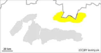
In the High and Western Tatras there is a MODERATE avalanche danger above the forest border (i.e. 2nd degree of the 5-part scale). Significant snowfalls were often blown by strong winds up to the forest zone. However, on the leeward sides of the mountains (especially SE and E), winds have locally created snow pillows and slabs, the stability of which may be low, especially on steep to very steep slopes. Avalanches can be released locally, especially by large additional loads. On the S side of the mountains at the highest altitudes, especially in steep and narrow couloirs, there is still a persistently weak layer of square-grained snow in the snow profile, which has not stabilised due to severe frosts. Small spontaneous avalanches may occur sporadically during the day, mainly from new snow, which will become heavier as the forecast warming warms up.
Snowpack
The weather during Wednesday will be influenced by an influx of warm air, with the 0°C isotherm gradually reaching the mid to high teens. Snow is very unevenly distributed in the terrain. Strong winds of the last few days have transported it to the SE and E sides of the mountains. The windward sides of the mountains will be blown onto a hard base layer of firn or up to the soil surface. During the day the snow will be melting and settling due to warming. Overall snow cover is still below average, conditions have improved at low elevations, but due to the powdery nature of the snow it is not yet load bearing.
Tendency
Enduring.
Danger level
treeline
Avalanche Problem
Wind slab
Treeline
Wet snow
Treeline
Watch for snow pillows on the leeward (V) sides of the mountains and snow accumulation during the day.
In the Low Tatras and Fatras there is a MODERATE avalanche danger above the forest border (i.e. 2nd degree of the 5-part scale). Significant snowfalls were often blown by strong winds up to the forest zone. However, on the leeward sides of the mountains (especially SE and E), winds have locally created snow pillows and slabs, the stability of which may be low, especially on steep to very steep slopes. Avalanches can be released locally, especially by large additional loads. Small spontaneous avalanches may occur sporadically during the day, mainly from new snow, which will become heavier as the forecast warms up.
Snowpack
The weather during Wednesday will be influenced by an influx of warm air, with the 0°C isotherm gradually reaching the mid to high teens. Snow is very unevenly distributed in the terrain. Strong winds of the last few days have transported it to the SE and E sides of the mountains. The windward sides of the mountains will be blown onto a hard base layer of firn or up to the soil surface. During the day the snow will be melting and settling due to warming. Overall snow cover is still below average, conditions have improved at low elevations, but due to the powdery nature of the snow it is not yet load bearing.