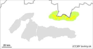
In the High and Western Tatras there is a moderate avalanche danger above 1800 m above sea level (level 2). Up to 15 cm of new snow has accumulated in the high altitudes of the High and Western Tatras. It fell in combination with very strong winds. The wind created slabs and pillows. The danger is concentrated in places where there is old snow under the slabs. These two layers could not bind well due to the low temperatures.
Snowpack
The snow cover consists of two distinct layers. Old, hard snow (crust) and about 10 - 15 cm of new snow. Sometimes even more. Temperatures are dropping below -10°C, so the layers cannot combine well. There is also a large temperature gradient in the snow cover, which can cause dangerous square-grained snow to form. Overall, however, the snow cover on the mountains is below average.
Tendency
Enduring.
Danger level
1500m
Avalanche Problem
Wind slab
1500m
Watch out for places with blown new snow.
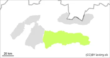
In the Low Tatras is declared a SMALL avalanche danger (1st degree). For the last period of snowfall up to 5 cm of new snow with strong wind. Locally snow slabs of small thickness may form. Due to the small amount of new snow, they may mainly cause shearing and falling. Increase caution in areas with accumulated large amounts of new snow.
Snowpack
The snow cover consists of two distinct layers. Old, hard snow (crust) and about 5 cm of new snow. In some places even more. Temperatures are dropping below -10°C, so the layers cannot combine well. There is also a large temperature gradient in the snow cover, which can cause the formation of dangerous square-grained snow. Continuous snow cover occurs in the Low Tatras from an altitude of about 1300 m and reaches 40 to 70 cm at the highest altitudes.