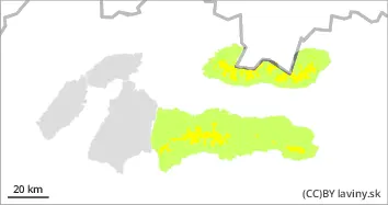
Watch out for avalanches from warming and windblown slabs.
After warming, rain and subsequent slight cooling at night, the snow profile stabilized fairly well up to 1800m above sea level. Above this level, the most serious problem is wind blown snow, where up to 10 cm of new snow has fallen in the last period. This can be wind-blown in the form of snow slabs and pillows on top of older, harder ground, which may not be well bonded. Avalanches are a risk, especially with high additional loads.
Snowpack
The snow surface on the southern orientations is mainly wind-beaten slabs, which have gradually stabilised due to settling and warming. On the other hand, in the northern orientations, warming and rain up to 2000 m a.s.l. have created a crust on the surface. Locally, a very hard to icy surface may alternate with a breaking crust. At the highest altitudes of the Tatra Mountains there is dry snow, locally rolled into snow slabs and pillows.
Tendency
Due to warming and rain rising
Danger level
Avalanche Problem
Wet snow
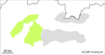
Beware of avalanches from wet snow.
The avalanche situation in the Fatra Mountains was relatively stabilized due to warming, rain and subsequent slight cooling at night. Especially steep and very steep places are dangerous, where avalanches from wet snow can form due to warming during the day. Especially in places where new snow lies on hard or grassy ground.
Snowpack
Snow cover is relatively well consolidated, moist to wet throughout the day. Crust has formed on the surface, locally hard snow in some places.