Danger level
 | 1700m |
|  |
|  |

![]()
Long lasting very strong winds - watch out for wind-blown snow on leeward sides.
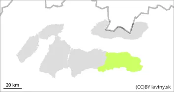
In the High, Western and Western part of the Low Tatras there is a moderate avalanche danger - 2nd degree. During Friday we expect a warm front to pass through in the afternoon, bringing gradual warming, precipitation and very strong winds. The wind will blow the loose snow to the leeward sides of the mountains (SE, SW, and SW) where it will deposit it in slabs of varying thickness and hardness. Their distribution will be very local - depending on the relief and the prevailing wind direction. Mostly under saddles, rock walls and in leeward troughs, where the snow will be deposited to a thickness of more than 50 cm. Avalanche release will be possible on very steep to extremely steep slopes, especially at higher additional loads.
Snowpack
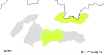
The cold sector will alternate with the passage of a warm front, it will still be very cold in the morning, but it will gradually warm up. Very strong winds are expected to continue throughout the day, reaching speeds of over 25 m/s (90 km/h). Snow will be blown by strong north winds into the forest zone, but it is also expected to be deposited on the leeward sides of saddle troughs and moguls. There is a settled layer of snow from the weekend snowfall on top of the old snowpack that has frozen. Strong winds will continue to deposit another layer of snow on top of this during Friday, which will be of low stability.
Tendency
with the expected development of the weather rising