Danger level
 | 1700m |
|  |
|  |

![]()
Beware of strong winds with snow - slab avalanches on the leeward sides.
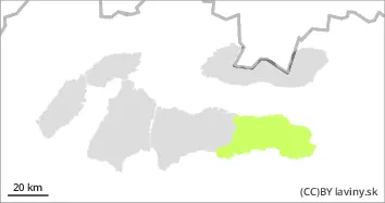
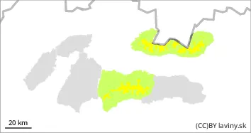
In the High, Western and Western part of the Low Tatras there is a moderate avalanche danger - 2nd degree. During Thursday, we expect a cold front to pass through, which will again bring cooling, precipitation and very strong winds. The wind will blow the new snow to the leeward sides of the mountains (SE and SW), where it will be deposited in slabs of varying thickness and hardness. Their distribution will be very local - depending on the relief and the prevailing wind direction. Often under saddles, rock walls and in leeward troughs, where new snow will be deposited to a thickness of more than 50 cm. Avalanche release is possible on very steep to extremely steep slopes, especially with higher additional loads.
Snowpack
A cold front will pass through during the night and be replaced by a cold sector, it will get colder again and we expect very strong winds reaching speeds of over 30 m/s (108 km/h). Temperatures will reach -17°C at the highest altitudes. Snow will be blown by strong north winds into the forest zone, but it is also expected to be deposited on the leeward sides of saddle troughs and moguls. There is a settled layer of snow from the weekend snowfall on top of the old snow cover that has frozen. Strong winds will deposit another layer of snow on top of it during Thursday, which will have low stability.
Tendency
With the predicted development of the weather rising.