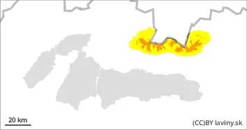
In the high altitudes of the Western and High Tatras (above 1700 m above sea level) there is still an INCREASED avalanche danger level 3. The last period of snowfall was accompanied by very strong winds. On the places where the snow was deposited (leeward sides of couloirs, saddles and leeward facing moguls), dangerous snow slabs and pillows of different thicknesses were formed. Their distribution is very local - depending on the relief and the prevailing wind direction. Avalanche release on such slopes, especially on steep slopes, is possible with only a small additional load. Occasionally, spontaneous, medium-sized avalanches are possible.
Snowpack
Over the weekend, an influx of Arctic air hit the hotter parts of Slovakia, causing severe cold, snow and strong winds. Winter conditions prevailed in the mountains, with air temperatures dropping to -10 to -21 °C. During the last period of snowfall (Saturday evening - Tuesday morning), 25 to 45 cm of new snow fell, but with very strong northerly winds of 25 m/s, gusting up to 35 m/s. The older snow cover is frozen and very hard, with new, mainly slabby snow of varying thickness on the surface, depending on the wind and the relief. A lot of the new snow has been blown by strong winds into the forest zone, where it is loose and powdery, 15-30 cm thick, but it has fallen directly on terrain without older snow.
Tendency
persistant
Danger level
1700m
Avalanche Problem
Wind slab
1700m
Watch out for localised, wind-wound boards and cushions.
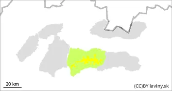
In the highest altitudes of the Low Tatras (above 1700 m above sea level) a MODERATE avalanche danger (2nd degree) was created due to snowfall and strong wind. Unstable snow slabs and pillows occur locally - especially under saddles, rock walls, in moguls and steep couloirs of the highest altitudes.
Snowpack
Over the weekend, an influx of Arctic air hit the hotter parts of Slovakia, causing severe cold, snow and strong winds. Winter conditions prevailed in the mountains, with air temperatures dropping to -8 to -15 °C. During the last snowfall (Saturday evening - Tuesday morning), 10 to 20 cm of new snow fell, but accompanied by very strong northerly winds of 25 m/s, gusting up to 35 m/s. The older snow cover is frozen to 'stone', and there is new, mainly slab snow of varying thickness - depending on the wind and the topography. Due to very strong winds, the snow has often been blown down to the mid-elevations and the forest zone, but where it has been deposited locally, there are unstable snow pillows and slabs.
Tendency
Persistant
Danger level
1700m
Avalanche Problem
Wind slab
1700m
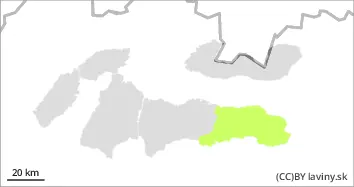
In the eastern part of the Low Tatras there is only a small avalanche danger, 1st degree. Avalanche release is possible only in exceptional cases on isolated leeward, very steep surfaces with a larger additional load.
Snowpack
Snow cover is low, only patchy or up to 5 cm thick up to 1600 m above sea level. At the highest altitudes, under the new wind-blown snow, there is older frozen snow up to 50 cm thick.