Due to the warming temperatures and predicted snowfall /rain/, the main avalanche problem is WET SNOW.
Moderate avalanche danger in the high altitudes of the High, Western and Low Tatras, 2nd degree. Small to medium-sized spontaneous avalanches from wet snow may occur on steep slopes during the day as the weather warms up. On north (shaded) slopes, in couloirs, under saddles and rock faces, there are hard snow slabs and pillows that are not sufficiently bonded to the ground. Avalanche release in these areas is possible, especially with high additional loads.
Snowpack
The snow cover is very variable, we expect snow showers during the night, from an altitude of 1300 m. During the day, the snowfall limit will rise up to 1800 m above sea level. Above this limit, new snow will be added, from 5 to 15 cm, below this the snow cover will diminish due to rain and the snow will be wet. On the northern slopes at high altitudes (above 2000 m), the snow remains dry, often in the form of hard slabs and pillows, and during the coming snowfall and strong southerly winds, another 10 to 20 cm of snow will be added. At altitudes below 1500 m, there is only a patchy snow cover.
Tendency
Slight worsening of the situation as the day warms up.
fk
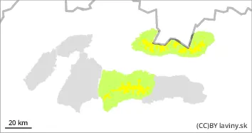
Danger level
1400m
Avalanche Problem
Wet snow
1400m
Beware of wet snow on steep slopes.
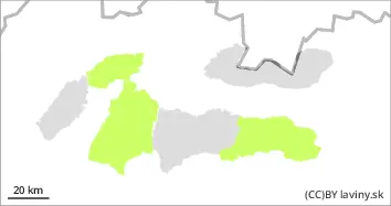
In Veľká and Mala Fatra and in the eastern part of the Low Tatras there is only a SMALL avalanche danger, 1st degree. As a result of rain, the occurrence of wet snow avalanches on steep slopes is possible.
Snowpack
The snow cover is only patchy at altitudes up to 1400 m above sea level, at higher altitudes - especially in troughs and kettles - it reaches a maximum of 50 cm. There is almost no snow on the southern slopes. The snow is wet all day due to rain and warming.
Tendency
During the day, the situation on the sunlit slopes deteriorates slightly.
fk