At the highest altitudes, watch out for blowing snow.
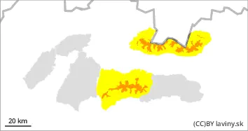
In the highest altitudes of the High, Western and Low Tatras, avalanche danger level 3 has been declared. During the last period of heavy precipitation, up to 30cm of new snow fell. It has been transported by the wind to the leeward slopes, especially to the northern orientations. Here, snow slabs and cushions of more than 50cm thick may be present and may not be well bonded to the ground. Avalanche release is already possible with a small additional load.
Snowpack
The biggest increment of new snow is from about 1700m above sea level where locally 30cm fell. The snowfall was gradual from rain and so most of the snow fell at the highest altitudes. Below 1700m the snow is moist to wet and will continue to get wet during the day due to the mild warming and sunshine. Wet avalanches and drifts may form.
Tendency
Gradually descending.
Danger level
Avalanche Problem
Wet snow
Wet snow.
In Veľká and Mala Fatra and in the eastern part of the Low Tatras, the 1st avalanche danger level has been declared. The snow is mostly packed and stable after a heavy period of rain. Small wet avalanches and avalanches may form, or very local foundation avalanches, where grass forms the base under more snow.
Snowpack
Snow is very patchy at lower elevations. Most of the snow is found on the shady and northern orientations of the mountains and the entire profile is waterlogged.