Significant warming during the day, with a rising threat of wet avalanches.
Avalanche danger will also increase significantly due to precipitation and warming. In the afternoon, the snowfall limit is expected to rise to 2000m above sea level. After this threshold, precipitation will be in the form of rain, which will significantly weaken the snow cover. Particularly dangerous will be places where there is loose snow from the previous snowfall. Northern orientations are particularly at risk, as southerly winds have been blowing in recent days.
Snowpack
The limit of continuous snow cover is around 1200m above sea level. The snow is wet from the morning hours due to the lack of night frosts. Due to warming, it will also get wet at higher altitudes. The wind-blown slabs and cushions from previous snowfall periods will mainly weigh down and lose cohesion with the underlying layer.
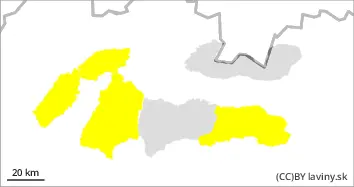
Tendency
Due to warming and rain rising.
Built by : Martin Bešinský
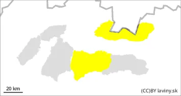
Danger level
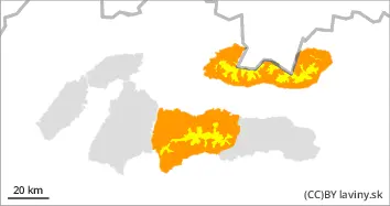
Avalanche Problem
Wet snow
Gliding snow
Formation of wet and foundation avalanches due to rain.
Avalanche danger will be strongly associated with all-day rain. This will further soak the already wet snow profile. Particularly dangerous are places where large amounts of snow have been deposited during the snowfall. On grassy steep slopes there is a high probability of foundation avalanches.
Snowpack
The snow profile is wet due to the plus temperatures. There is no overnight frost up to 1500m above sea level to harden the wet cover. The boundary of the continuous snow layer is somewhere around 1200m above sea level.