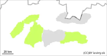
Danger level
 | 1800m |
|  |
|  |

![]()
In the highest altitudes of the High, Western and western part of the Low Tatras there is a moderate avalanche danger, i.e. 2 degree from the 5-part international scale. The main avalanche problem is wind-blown snow from the last snowfall period (Sunday-Monday). Generally the snow was blown by very strong winds to lower elevations and forest, but at the highest elevations it was also deposited on the leeward SE,E and SW sides of the mountains in narrow couloirs or terrain depressions in unstable slabs and pillows. These formations can be loosened mainly by large additional loads on steep to extremely steep slopes. A clear night will cause freezing and hardening of the snow cover, therefore a low avalanche danger (level 1) applies at lower altitudes. Only light precipitation is expected during the day, which will be of a snow-like character from middle altitudes. Due to very strong winds, drifts have formed on the ridges and may pose a danger.
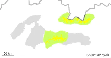
Snowpack
The snow cover is generally packed and hardened due to the alternation of plus daytime and negative night temperatures. At the highest altitudes on the leeward sides of the mountains, new snow from the last snowfall is blown over the old hard snow cover in the form of brittle slabs and pillows. Crust has formed on the S sides due to Tuesday's warming and overnight cooling.
Tendency
With the expected alternation of plus daytime and negative nighttime temperatures decreasing.