Danger level
 | treeline |
|  |
|  | ||||
|  |  |


![]()
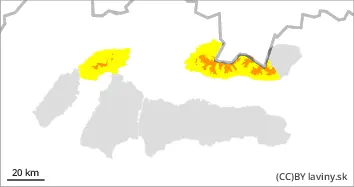
The fresh snow is transported and deposited on the leeward slopes in the form of snow slabs.
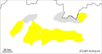
In Mala Fatra, in the Western Tatras and in the western part of the High Tatras, CONSIDERABLE avalanche danger level (3) has been created over the forest zone due to very strong wind and new snow. Especially the northern exposures with loose, slab snow are dangerous, also steep slopes under rock walls and places with a significant change of slope. Avalanche release is possible with only a small additional load; spontaneous avalanches are also possible.
Snowpack
During Monday and especially Tuesday, 20-40 cm of new, powder snow fell in the area. However, this is already being transported to the leeward, mainly northern slopes during Wednesday. Here it is deposited in variously hard snow slabs, which are prone to avalanche when loaded. It will warm up considerably during the day, with isotherms of 0°C rising to above 1600 m above sea level in the afternoon and evening. Snow at lower and middle altitudes will become wetter and set. At altitudes up to 1000 m above sea level, new snow will be directly on the ground, without any old snow.
Tendency
Persistent
Compiled by Filip Kyzek