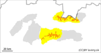
There is an CONSIDERABLE avalanche danger in the Western Tatras and in the west of the Low and High Tatras (level 3). Due to the westerly flow, most new snow has been added in the western parts of the Tatras. In the last 3 days up to 50 cm of new snow. The snowfall limit varied but above 1500 m above sea level the temperatures were still below 0°C. Very strong north-westerly wind persists. The main problem is therefore wind blown snow. The steep troughs of the highest altitudes are dangerous, where the wind has deposited snow slabs and cushions and created cornices. Due to the strong winds, we do not recommend long and difficult hikes on the ridges. Below the 1500 m mark, mostly wet snow fell, which bound well with the ground.
Snowpack
Above 1500 m above sea level, the snow cover is dry and wind-beaten into slabs. Below this layer there is a soft layer of felted and angular snow. It is this combination that is dangerous from the point of view of avalanches. Beneath these layers is very hard to icy snow that has formed since the Christmas thaw. The limit of continuous snow cover has risen to about 1000 m above sea level.
Tendency
Stays the same.
Danger level
1300m
Avalanche Problem
Wind slab
1300m
Wet snow
1300m
Watch out for new snow and wind-blown hard slabs of new snow.
There is a moderate avalanche danger in the Fatra Mountains, i.e. level 2 above 1300 m a.s.l. Up to 30 cm of new snow has been added to the hard old snow surface in the last 3 days. Strong winds of different directions persist. The main problem is therefore wind-blown snow. The steep slopes of the highest altitudes are dangerous, where the wind has deposited snow slabs and pillows during the day and created cornices. Due to the strong winds, we do not recommend long ridge hikes. Below 1300 m, mostly wet snow fell, which is well bonded to the ground.
Snowpack
The old snow cover has hardened due to the changing temperatures. A thick layer of ice has formed on its surface. Up to 20 cm of new snow has been added, which will be very unevenly distributed due to the wind. The large difference in hardness between the old snow cover and the new snow has caused instability in the snow profile. There are several crusts deeper in the profile, but these do not affect the avalanche situation. Below 1300 m the snow is mostly wet.
Tendency
Stays the same
Danger level
1700m
Avalanche Problem
Wind slab
1700m
Watch out for new snow and wind-blown hard slabs of new snow.
In the east of the Tatras and Low Tatras there is a moderate avalanche danger, i.e. level 2 above 1600 m a.s.l. A relatively small amount of snow (from 5 to 20 cm) has been added to the hard old snow cover over the last 3 days. The further east you go the less new snow there is. A strong north-westerly wind persists. Wind-blown snow is therefore the main problem. The steep troughs of the highest altitudes are dangerous, where the wind has deposited smaller snow slabs and pillows during the day and created overhangs. Due to bad weather, wind, fog and snowfall we do not recommend long and difficult hikes on the ridges. Below the 1600m mark, mostly wet snow fell, which bound well with the ground.
Snowpack
The old snow cover in all mountain ranges has hardened and hardened due to temperature changes. A thick layer of ice has formed on its surface. Up to 20 cm of new snow has been added, which is very unevenly distributed due to the wind. The large difference in hardness between the old snow cover and the new snow has caused instability in the snow profile. There are several crusts deeper in the profile, but these do not affect the avalanche situation.