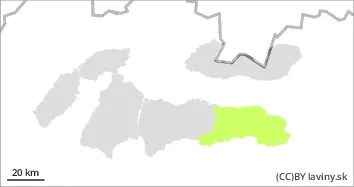
Danger level
 | treeline |
|  |
|  |

![]()
Cooling down after warming up - hard conditions challenging to slip on.
In the High, Western, Western part of the Low Tatras and Fatras there is a moderate avalanche danger, i.e. 2nd degree from the 5-part international scale. During the night and Wednesday, the edge of high air pressure will move into the mountains of Slovakia, which will bring cooling. Temperatures will drop back below freezing overnight, which will have a positive effect on the stability of the snow cover. The arrival of cold air will be accompanied by strong westerly winds, especially in the morning. The main avalanche problem is thus wind-drifted snow on the northeast, east and southeast orientations of the slopes above the tree line. In such places, especially on very steep leeward slopes, there are local slabs and pillows of unstable packed snow lying on frozen ground.
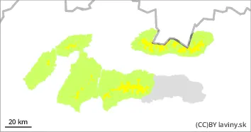
Snowpack
During the warming period (Sunday afternoon to Tuesday afternoon), the snow cover in all mountains of Slovakia became wet and significantly lost its height. The loss in snow cover height averaged 15-25cm per 24 hours. After the overnight cooling, a crust formed on the surface of the cover at lower altitudes and an ice layer at higher altitudes. Only at the highest altitudes can still be found dry, unprocessed snow, which has been transported by strong winds to the leeward sides of the slopes and is stored in local pillows and slabs.
Tendency
Declining due to cooling and the assumption of calming strong winds.